Terrain
Drawing terrain with realistic (or not) transitions between adjacent tiles is a complex problem. Freeciv21
comes with several patterns that can be used to build complex terrain schemes. They are specified in the
main .tilespec file of the tileset, under the [tile_*] and [layer*] sections.
Terrain rendering is done in several independent passes, each of them having its own layer in the main
tileset configuration file, Terrain1 through Terrain3. This allows several sprites to be combined in
the drawing of a single tile, which is one of the ways to break monotony.
Each terrain specified in a ruleset must have a graphic tag name, and optionally a graphic_alt tag.
This information is used to search for compatible sprites in the tileset, first using graphic and, if
it fails, graphic_alt.
Todo
Documentation is still missing for:
Sprite dimensions, in particular in hexagonal mode where it is counter-intuitive.
Blending.
The mask sprite and what happens at the edge of the map.
A general introduction to the structure (
[layer*]and[tile_*]sections). Some of this is already there at the bottom of but would need reformatting.
Sprite type single
In this mode, each tile is drawn using a single sprite. The sprites should have dimensions
normal_tile_width times normal_tile_height. It is possible to augment the size by setting
layerN_is_tall to TRUE, in which case the height is expanded by 50% above the tile. This can be used
to render graphical elements like trees and mountains that hide terrain behind them.
It is possible to set arbitrary offsets on a per-terrain basis using layerN_offset_x (positive values move
the sprite to the right) and layerN_offset_y (positive values move the sprite down). These options should
be used with caution, because pixels drawn outside of the area covered by a “tall” tile will confuse the
renderer and cause artifacts.
Note
whole is a synonym for single; single is preferred.
Without matching
The name of the sprites used by sprite type single depend on the number of terrain groups included in
matches_with. When no matching is performed, sprites names are built according to the following pattern:
t.l<n>.<tag><i>
The value <n> is replaced with the layer number, and <tag> with the terrain tag. The last element,
<i>, is a number starting from 1: if several sprites are provided with numbers 1, 2, …, the renderer
will pick one at random for every tile. This can be used to provide some variation, either by changing the
base terrain sprite or by overlaying decorations on top.
Example
The following is the minimal definition for a terrain type: no matching is performed, and a single sprite is sufficient:
[tile_desert]
tag = "desert"
num_layers = 1
The base sprite would have tag t.l0.desert1; additional sprites called t.l0.desert2, t.l0.desert3,
etc., can also be added, in which case one will be picked at random for every tile.
With matching
Sprite type single also supports matching against the same group as the represented terrain is in. For
instance, if one group is used for land, a second group for sea tiles, and a third group for ice, the sprite
used for ice tiles can depend on the presence of ice on adjacent tiles — but when there is no ice, one
cannot know whether the other tile is land or water. In this case, the pattern is as follows:
t.l<n>.<tag>_<directions>
Like in the unmatched case, <n> is replaced with the layer number and <tag> with the terrain tag. The
<directions> part indicated which in which directions a match has been achieved, as a list of directions
followed by 0 (no match) or 1 (match). The directions depend on the tileset geometry:
For square tilesets, they are North, East, South, and West, and thus the
<directions>part looks liken0e1s1w0. There are 16 sprites in total.Isometric hexagonal tilesets also have South-East and North-West, and the
<directions>part looks liken0e1ne0s1w0nw0. There are 64 sprites.Non-isometric hexagonal tilesets use North-East and South-West instead, for instance
n0ne0e1s1sw1w0. There are also 64 sprites.
Matching Example
In many tilesets, the sprites used for hills and mountains depend on the presence of other hills and mountains
on adjacent tiles. This is achieved by putting them in a single matching group, usually called hills:
[layer1]
match_types = "hills"
We use layer 1 in this example because something is typically drawn under the hills for coasts and blending. The next step is to put hills and mountains in the group and enable matching:
[tile_hills]
tag = "hills"
num_layers = 2
layer1_match_type = "hills"
layer1_match_with = "hills"

[tile_mountains]
tag = "mountains"
num_layers = 2
layer1_match_type = "hills"
layer1_match_with = "hills"
With these settings, both hills and mountains will match adjacent tiles if they have hills or mountains.
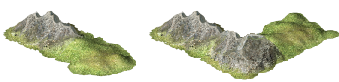
Fig. 83 Hills and mountains in amplio2 use the pattern described above.
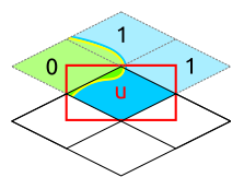
Sprite type corner
The corner sprite type divides each tile in four smaller parts that are adjacent to only three tiles.
This allows matching with diagonal tiles, which would be impractical in single mode due to the large
number of sprites required. Corner mode was developed primarily for square isometric tilesets, but it can
also be used with other topologies, as shown in the diagram below:
Fig. 84 Definition of the corners for the four tileset topologies: square isometric (top left), square (top right), hexagonal isometric (bottom left), and hexagonal (bottom right).
For square topologies, the corner sprites (colored rectangles) cover a slice of the tile area adjacent to three other tiles. Matching takes place with respect to each of them, which enables complicated designs while requiring comparatively small numbers of small sprites. For isometric hexagonal tilesets, some slices are adjacent to two tiles and some to three; it is recommended that new tilesets use hex_corner instead.
The four corners are identified using the letters shown in the diagram, which stand for their location in
isometric mode: up, down, left, and right. The names used in the .spec files depends on the number of
groups listed in matches_with and, when a single group is listed, of the group matching is performed
against. This naming scheme is explained in the next sections.
Without matching (single)
Warning
Using corner sprites without matching is fully equivalent to a single sprite, except that performance
is likely to be worse and the naming convention is harder to track. Avoid using this mode.
When no matching is performed, four corner sprites are required for each terrain. They are expected to be
half the size of a normal tile in both dimensions, and use the following naming scheme:
t.l<n>.<tag>_cell_<direction>
The value <n> is replaced with the layer number, and <tag> with the terrain tag. The last part,
<direction>, indicates which corner the sprite refers to.
Matching with the same group
This mode is used when a single matching group is specified in the matches_with list, and it is the same
as match_type. This is often used to draw beaches, because they are drawn where neighboring tiles are
anything but water. 32 sprites are required for each tag, with the following naming convention:
t.l<n>.<tag>_cell_<direction><01><01><01>
The value <n> is replaced with the layer number, and <tag> with the terrain tag. Sprites must be
provided for each of the four possible values of <direction>: u, d, l, and r, that
indicate which corner the sprites are for. The three remaining parts, <01>, each correspond to the
matching status of one of the adjacent tiles, counting clockwise. 0 means that the tile is not matched,
and 1 that it is.
For instance, the suffix of u011 corresponds to the following situation, where blue represents the group
of the tile being rendered (black frame) and green is some other terrain:
Group Example
Simple coasts can be drawn as follows:
[layer0]
match_types = "water"

[tile_coast]
tag = "coast"
num_layers = 1
layer0_match_type = "water"
layer0_match_with = "water"
layer0_sprite_type = "corner"

[tile_floor]
tag = "floor"
num_layers = 1
layer0_match_type = "water"
layer0_match_with = "water"
layer0_sprite_type = "corner"

[tile_lake]
tag = "lake"
num_layers = 1
layer0_match_type = "water"
layer0_match_with = "water"
layer0_sprite_type = "corner"
This requires 96 sprites, 32 for each tile type.
Matching a pair of groups
This mode is used when a single matching group is specified in the matches_with list, and it is different
from match_type: a neighbor tile matches only if it is in the specified group. This can be used in a
similar role as matching with the same group, but is sometimes more convenient
(especially when a layer starts to have many groups). This mode requires 32 sprites per tag and uses the
following naming convention:
t.l<n>.<tag>_cell_<direction>_<g>_<g>_<g>
The value <n> is replaced with the layer number, and <tag> with the terrain tag. Sprites must be
provided for each of the four possible values of <direction>: u, d, l, and r, that
indicate which corner the sprites are for. The three remaining parts, <g>, each correspond to the first
letter of a matching group of one of the adjacent tiles, counting clockwise. If there was a match, the first
letter of the group in matches_with is used; otherwise, it is the first letter of match_type.
Warning
Extra care is needed when drawing sprites for this mode; see the example for guidance.
Groups Example
Suppose that you have a tileset where mountains are drawn as solid rock. It would then make sense to draw cliffs instead of beaches where the mountains meet water, as below:
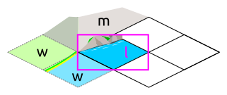
Fig. 85 Cliffs
This can be achieved by drawing the mountains and the sea normally in the first layer, and overlaying the cliffs in the second layer. In this example, the cliffs are drawn on top of the water (the mountains advance into the sea):
[layer2]
match_types = "water", "mountains"

[tile_coast]
tag = "coast"
num_layers = 2
layer1_match_type = "water"
layer1_match_with = "mountains"
layer1_sprite_type = "corner"

[tile_mountains]
tag = "mountains"
num_layers = 1
layer1_match_type = "mountains"
The sprite shown above would be called t.l1.coast_cell_l_w_w_m (left side, water, water, and mountains
when enumerating clockwise): even though the tile on the left is not water, it is still identified as such
because it is not in the group given in match_with.
Because the tile on the left is identified with water, there is no way to distinguish between the following situations:
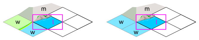
Fig. 86 Indistinguishable cases when using pair matching.
Because of this, sprites need to be designed to work in several cases (the tile at the bottom could also be either land or water). In the example above, the cliff vanishes at the corner, which allows it to merge with the land and is also a plausible behavior when there is only water around.
General matching
When more than one element is present in the matches_with list, general matching is used. This mode uses
sprites that cover the intersection between four tiles:
The sprites have the same size as a normal tile, but are drawn with an offset equal to one half of a tile, such that they are centered around the meeting point of the tiles.
The sprite naming convention uses only the names of the four groups the tiles are in. Unlike with other modes, the terrain tag is not used:
t.l<n>.cellgroup_<g>_<g>_<g>_<g>
The value <n> is replaced with the layer number. The four remaining parts, <g>, each correspond to
the first letter of one of the groups specified in matches_with, specified in clockwise order starting
from top (referring to the above schema, u, r, d, and l).
Note
General matching is a very flexible mode that lets one draw very complex terrain, but this comes at the cost of a large number of sprites: for three groups, 81 sprites are needed; for four groups, it raises to 256; and to use four groups, one would need to draw 625 sprites.
Sprite type hex_corner
Added in version 3.0: Use the +hex_corner option in tilesets requiring this feature.
Added in version 3.1: Support for matching against the group the tile is in.
The hex_corner sprite type provides functionality similar to corner, using a geometry optimized for
isometric hexagonal tilesets. Hexagonal corner sprites cover one half of the height of the hexagons and are
centered vertically within the tiles. They come in two types: “left” corners cover the left hand side of an
hexagon and the right hand side of the border between two others; “right” corners have a similar geometry,
but are flipped horizontally. When drawn in a checkerboard pattern, left and right sprites reconstruct the
complete hexagons.
Fig. 87 The geometry of hexagonal corner sprites.
Matching with the same group (corner)
Similarly to the corresponding mode for square tilesets, this mode is used when
matches_with only contains match_type. 14 sprites per terrain tag are needed to cover all the
variations. They are named as follows:
t.l<n>.<tag>_hex_cell_left_<01>_<01>_<01>
For “right” sprites, simply replace left with right. The value of <n> gives the layer number, and
the three <01> indicate whether the three tiles around the corner are in the specified matching group.
The order is given by the letters a, b, and c in the figure above.
Matching with more than one group
This corresponds to the general mode for square tilesets. The naming convention for “left” sprites is as follows:
t.l<n>.hex_cell_left_<g>_<g>_<g>
For “right” sprites, simply replace left with right. The value of <n> gives the layer number, and
the three <g> each correspond to the first letter of a matching group. For “left” sprites, the first
group corresponds to the tile of the right, the second to the tile at the top left, and the third group is the
one of the tile at the bottom left. For “right” sprites, the tile on the left comes first, followed by the
one at the top right and the tile at the bottom right. The order is indicated by the letters a, b, and
c in the figure above.
Multiple Group Example
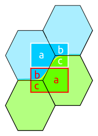
Fig. 88 Coasts using hex_corner sprites.
To draw coasts using hex_corner, one starts by defining two matching groups land and water:
[layer0]
match_types = "land", "water"
Each land terrain must be declared within the land matching group, while seas and lakes go to water:
[tile_coast]
tag = "coast"
num_layers = 1
layer0_match_type = "water"
layer0_match_with = "land", "water"
layer0_sprite_type = "hex_corner"

[tile_plains]
tag = "plains"
num_layers = 1
layer0_match_type = "land"
layer0_match_with = "land", "water"
layer0_sprite_type = "hex_corner"

; etc
With these settings, the two sprites shown in the figure are called t.l0.hex_cell_right_w_w_l for the one
above (white), and t.l0.hex_cell_left_l_w_l for the one below (red).
Terrain Options
The top-level .tilespec file also contains information on how to draw each terrain type (grassland,
ocean, swamp, etc.). For each terrain type include a section [tile_xxx]. This section contains
information on how to draw this terrain type. The terrain types are specified in the server ruleset
file.
[tile_XXX] options:
tag: Tag of the terrain this drawing information refers to. That must match the “graphic” or “graphic_alt” field given in the ruleset file.blend_layer: If non-zero, given layer of this terrain will be blended with adjacent terrains. Blending is done civ2-style with a dither mask. Only iso-view currently supports blending. Only the base graphic will be blended. The blending mask has spritet.dither_tile.num_layers: The number of layers in the terrain. This value must be 1, 2 or 3. Each layer is drawn separately. The layerN options below control the drawing of each layer (N should be 0, 1 or 2)layerN_match_type: If 0 or unset, no terrain matching will be done and the base sprite will be drawn for the terrain. If non-zero, then terrain matching will be done. A matched sprite will be chosen that matches all cardinally adjacent tiles whose terrain has the same match_type.layerN_match_with: List of match_types to match againstlayerN_sprite_type: With traditional tilesets each tile is drawn using one sprite. This defaultsprite_typeis “whole”. Which sprite to use may be specified using amatch_group, and there may be multiple layers (each having one sprite). This method corresponds tosprite_type“single”. A more sophisticated drawing method breaks the tile up into 4 rectangles. Each rectangular cell is adjacent to 3 different tiles. Each adjacency is matched, giving 8 different sprites for each of the 4 cells. Thissprite_typeis “corner”.
Additionally the top-level .tilespec file should contain information about the drawing of each layer.
This is needed because the way each layer is drawn must be consistent between different terrain types. You may
not have more than 3 layers (either in this section or in the [tile_XXX] sections).
[layerN] Options:
match_types: Gives a string list of all different match types. This list must include every possible match_type used by terrains for this layer. First letter of the match_type must be unique within layer.